Tag: geographical
-
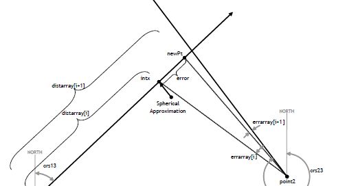
𝐓𝐄𝐑𝐏𝐒 𝐒𝐭𝐚𝐧𝐝𝐚𝐫𝐝 𝐅𝐨𝐫𝐦𝐮𝐥𝐚𝐬 𝐟𝐨𝐫 𝐆𝐞𝐨𝐝𝐞𝐭𝐢𝐜 𝐂𝐚𝐥𝐜𝐮𝐥𝐚𝐭𝐢𝐨𝐧𝐬 (8260.58) – The following FAA standard formulas with test cases passing have recently been implemented to our Aviation SDK: WGS84CrsIntersect – Computes the coordinates where two geodesic curves intersect WGS84Destination – Computes destination point based on course and a static point WGS84PtIsOnGeodesic – Algorithm determines if a point lies on and within…
-
This is a large part in the SDK which covers many different aspects including coordinate conversions between different map projects, ability to create simply graphical types (Lines, Polygon, etc) and then display on the graphics system of your choice. Specific features in the SDK do create a collection of these geo types for you to…